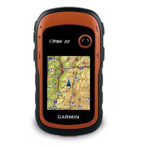
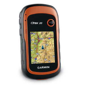
Garmin eTrex 20 Latest Mapping Handheld GPS
Garmin eTrex 20 takes one of the most popular and reliable GPS handhelds and makes it better. Redesigned ergonomics, an easier-to-use interface, paperless geocaching and expanded mapping capabilities add up to serious improvements for an already legendary GPS handheld. Garmin eTrex 20 is versatile. It’s tough. And it’s built to handle whatever Mother Nature can dish out – and more.
See The Way
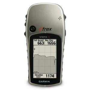
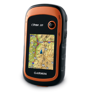
Garmin eTrex 20 has an enhanced 2.2 in 65K color, sunlight readable display. Durable and waterproof, eTrex 20 is built to withstand the elements. It has an upgraded interface yet retains its legendary toughness to withstand the elements – be it dust, dirt, humidity or water, none of which are a match for this storied navigator.
Go Anywhere
With an array of compatible mounts, Garmin eTrex 20 is designed for use on ATV’s, bicycles, in boats, as a handheld or in your car. Use the auto mount capability and City Navigator NT® maps for turn-by-turn driving directions, or the rugged mount for your motorcycle or ATV. Wherever you think you might take eTrex, it has the mapping and mounts to get you there.
Go Global
The new eTrex series is the first-ever consumer-grade receivers that can track both GPS and GLONASS satellites simultaneously. GLONASS is a system developed by the Russian Federation that will be fully operational in 2012. When using GLONASS satellites, the time it takes for the receiver to “lock on” to a position is (on average) approximately 20 percent faster than using GPS. And when using both GPS and GLONASS, the receiver has the ability to lock on to 24 more satellites than using GPS alone.
Add Maps
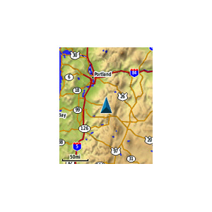
With its microSD™ card slot and 1.7 GB of internal memory, eTrex 20 lets you load TOPO 24K maps and hit the trail, plug in BlueChart® g2 preloaded cards for a great day on the water or City Navigator NT® map data for turn-by-turn routing on roads (see maps tab for compatible maps). Garmin eTrex 20 also supports BirdsEye™ Satellite Imagery (subscription required), that lets you download satellite images to your device and integrate them with your maps.
Keep Your Fix
With its high-sensitivity, WAAS-enabled GPS receiver and HotFix® satellite prediction, eTrex locates your position quickly and precisely and maintains its GPS location even in heavy cover and deep canyons.
Find Fun
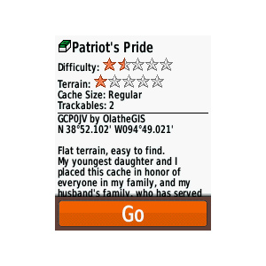
eTrex 20 supports geocaching GPX files for downloading geocaches and details straight to your unit. Visit OpenCaching.com to start your geocaching adventure. By going paperless, you’re not only helping the environment but also improving efficiency. eTrex 20 stores and displays key information, including location, terrain, difficulty, hints and descriptions, which means no more manually entering coordinates and paper print outs. Simply upload the GPX file to your unit and start hunting for caches.
[/vc_tab][vc_tab title=”Features” tab_id=”features”]
Paperless Geocaching
Spend more time in the field and less time fumbling with paper! The eTrex stores and displays key information, including location, terrain, difficulty, hints and descriptions, which means no more manually entering coordinates and paper print outs. Simply upload the geocaching GPX file to your unit and start hunting for caches.

Track More Satellites
Find your way with the first consumer-grade GPS receiver that tracks both GPS and Russian Federation GLONASS satellites simultaneously. When using them together, the receiver has the ability to lock onto 24 more satellites than using GPS alone, ensuring you can “lock on” to a position more quickly.

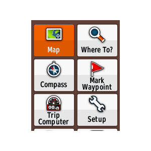
Pick Your Profile
Customize eTrex for every occasion. Profiles allow eTrex to quickly switch into different configurations that you create, so when you’re done geocaching and you need to drive home, your eTrex won’t miss a beat.

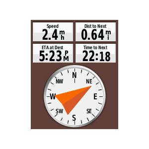
More Dashboards in More Places
Bring more functionality into your frequently used applications with dashboards. Avoid switching between applications and display more information by customizing them with an altimeter, compass, configurable data fields and more.
![]()
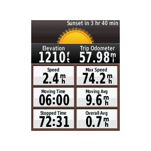
Advanced Tracking
Whether following a saved route or planning a new one, eTrex has the tracking features you need. Users can see high and low elevation points or store waypoints along a track (start, finish and high/low altitude) to estimate time and distance between points.

Extensive Map Support
With its microSD™ card slot and large internal memory, eTrex lets you load a variety of maps, including TOPO 24K, BlueChart® g2, City Navigator NT® and BirdsEye™ Satellite Imagery (subscription required).
New Device – Same Name and Quality
- Stores data in universally accepted GPX file format so its compatible with a variety of PC applications; best when used with Garmin’s free trip planning software, BaseCamp™.
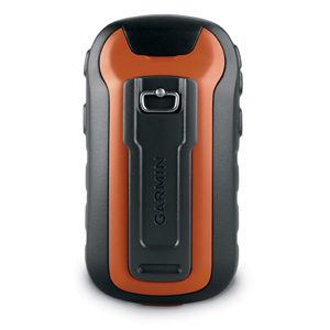
- Includes a worldwide basemap, improved interface and added support for spine mounting.
- Withstands the elements – be it dust, dirt, humidity or water.
- Locates your GPS position quickly and precisely and maintains it even in heavy cover and deep canyons.
- Mounts easily in ATVs, boats, bicycles or cars (compatible mounts sold separately).
Physical & Performance: |
|
| Unit dimensions, WxHxD: | 2.1″ x 4.0″ x 1.3″ (5.4 x 10.3 x 3.3 cm) |
| Display size, WxH: | 1.4″ x 1.7″ (3.5 x 4.4 cm); 2.2″ diag (5.6 cm) |
| Display resolution, WxH: | 176 x 220 pixels |
| Display type: | transflective, 65-K color TFT |
| Weight: | 5 oz (141.7 g) with batteries |
| Battery: | 2 AA batteries (not included); NiMH or Lithium recommended |
| Battery life: | 25 hours |
| Waterproof: | yes (IPX7) |
| Floats: | no |
| High-sensitivity receiver: | yes |
| Interface: | USB |
Maps & Memory: |
|
| Basemap: | yes |
| Preloaded maps: | no |
| Ability to add maps: | yes |
| Built-in memory: | 1.7 GB |
| Accepts data cards: | microSD™ card (not included) |
| Waypoints/favorites/locations: | 2000 |
| Routes: | 200 |
| Track log: | 10,000 points, 200 saved tracks |
Features & Benefits: |
|
| Automatic routing (turn by turn routing on roads): | yes (with optional mapping for detailed roads) |
| Electronic compass: | no |
| Touchscreen: | no |
| Barometric altimeter: | no |
| Camera: | no |
| Geocaching-friendly: | yes (paperless) |
| Custom maps compatible: | yes |
| Photo navigation (navigate to geotagged photos): | yes |
| Outdoor GPS games: | no |
| Hunt/fish calendar: | yes |
| Sun and moon information: | yes |
| Tide tables: | no |
| Area calculation: | yes |
| Custom POIs (ability to add additional points of interest): | yes |
| Unit-to-unit transfer (shares data wirelessly with similar units): | no |
| Picture viewer: | no |
| Garmin Connect™ compatible (online community where you analyze, categorize and share data): | yes |
What’s in the Box:
- eTrex 20
- USB cable
- Manual