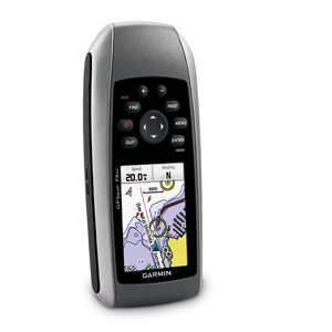
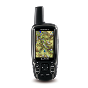
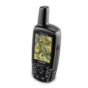
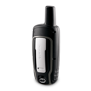
Garmin GPSMAP 62st Mapping Handheld GPS

The newly designed Garmin GPSMAP 62st handheld navigator features a 3-axis tilt-compensated compass, a barometric altimeter, preloaded TOPO 100K maps and supports custom maps, BirdsEye™ Satellite imagery (subscription required) and photo navigation. Rugged and waterproof, Garmin GPSMAP 62st employs a quad helix antenna for unparalleled reception, has a high-speed USB connection, a sleek new design and connects wirelessly to compatible Garmin handhelds.
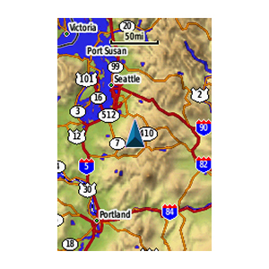
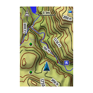
Explore the Terrain
The Garmin GPSMAP 62st comes preloaded with TOPO 100K, which includes coverage of the full U.S., including Alaska, Hawaii and Puerto Rico, and a worldwide basemap with shaded relief — all the tools for serious climbing or hiking. Map detail includes national, state and local parks and forests, along with terrain contours, elevation information, trails, rivers, lakes and points of interest.
Get Your Bearings
Garmin GPSMAP 62st has a built-in 3-axis tilt-compensated electronic compass, which shows your heading even when you’re standing still, without holding it level. Its barometric altimeter tracks changes in pressure to pinpoint your precise altitude, and you can even use it to plot barometric pressure over time, which can help you keep an eye on changing weather conditions.
Share Wirelessly
With Garmin GPSMAP 62st you can share your waypoints, tracks, routes and geocaches wirelessly with other compatible Garmin device users. So now your friends can also enjoy your favorite hike or cache — simply press “send” to transfer your information to similar units, and let the games begin.
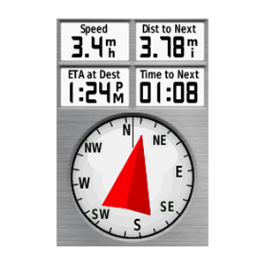
Keep Your Fix
With its quad helix antenna and high-sensitivity, WAAS-enabled GPS receiver and HotFix® satellite prediction, Garmin GPSMAP 62st locates your position quickly and precisely and maintains its GPS location even in heavy cover and deep canyons. The advantage is clear — whether you’re in deep woods or just near tall buildings and trees, you can count on Garmin GPSMAP 62st to help you find your way when you need it the most.
Add Maps
Adding more maps is easy with Garmin’s wide array of detailed topographic, marine and road maps. With its onboard memory, Garmin GPSMAP 62st lets you conveniently download TOPO 24K maps and hit the trail, plug in BlueChart® g2 preloaded cards for a great day on the water orCity Navigator NT® map data for turn-by-turn routing on roads (see maps tab for compatible maps). Garmin GPSMAP 62st also supports BirdsEye™ Satellite Imagery (subscription required), that lets you download satellite images to your device and integrate them with your maps. In addition, the 62st is compatible with Custom Maps, free software that transforms paper and electronic maps into downloadable maps for your device.
Get Connected
You’ve been busy exploring and now you want to store and analyze your activities. With a simple connection to your computer and to the Internet, you can get a detailed analysis of your activities and send tracks to your outdoor device using Garmin Connect™. This one-stop site offers an activity table and allows you to view your activities on a map using Google™ Earth. Explore other routes uploaded by millions of Garmin Connect users and share your experiences on Twitter® and Facebook®. Getting started is easy, so get out there, explore, and share.
Find Fun
GPSMAP 62st supports geocaching GPX files for downloading geocaches and details straight to your unit. By going paperless, you’re not only helping the environment but also improving efficiency. Garmin GPSMAP 62st stores and displays key information, including location, terrain, difficulty, hints and descriptions, which means no more manually entering coordinates and paper print outs! Simply upload the GPX file to your unit and start hunting for caches. Slim and lightweight, 62st is the perfect companion for all your outdoor pursuits.
[/vc_tab][vc_tab title=”Specifications” tab_id=”specifications”]
Physical & Performance: |
|
| Unit dimensions, WxHxD: | 2.4″ x 6.3″ x 1.4″ (6.1 x 16.0 x 3.6 cm) |
| Display size, WxH: | 1.43″ x 2.15″ (3.6 x 5.5 cm); 2.6″ diag (6.6 cm) |
| Display resolution, WxH: | 160 x 240 pixels |
| Display type: | transflective, 65-K color TFT |
| Weight: | 9.2 oz (260.1 g) with batteries |
| Battery: | 2 AA batteries (not included); NiMH or Lithium recommended |
| Battery life: | 20 hours |
| Waterproof: | yes (IPX7) |
| Floats: | no |
| High-sensitivity receiver: | yes |
| Interface: | high-speed USB and NMEA 0183 compatible |
Maps & Memory: |
|
| Basemap: | yes |
| Preloaded maps: | yes (topographic) |
| Ability to add maps: | yes |
| Built-in memory: | 500 MB |
| Accepts data cards: | microSD™ card (not included) |
| Waypoints/favorites/locations: | 2000 |
| Routes: | 200 |
| Track log: | 10,000 points, 200 saved tracks |
Features & Benefits: |
|
| Automatic routing (turn by turn routing on roads): | yes (with optional mapping for detailed roads) |
| Electronic compass: | yes (tilt-compensated, 3-axis) |
| Touchscreen: | no |
| Barometric altimeter: | yes |
| Camera: | no |
| Geocaching-friendly: | yes (paperless) |
| Custom maps compatible: | yes |
| Photo navigation (navigate to geotagged photos): | yes |
| Outdoor GPS games: | no |
| Hunt/fish calendar: | yes |
| Sun and moon information: | yes |
| Tide tables: | yes |
| Area calculation: | yes |
| Custom POIs (ability to add additional points of interest): | yes |
| Unit-to-unit transfer (shares data wirelessly with similar units): | yes |
| Picture viewer: | yes |
| Garmin Connect™ compatible (online community where you analyze, categorize and share data): | yes |


What’s in the Box:
- Garmin GPSMAP 62st
- Carabiner clip
- USB cable
- Manual[/fusion_checklist]
 [/vc_tab][vc_tab title=”Video” tab_id=”video”]