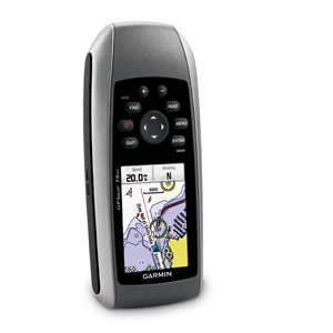
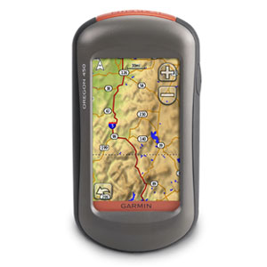
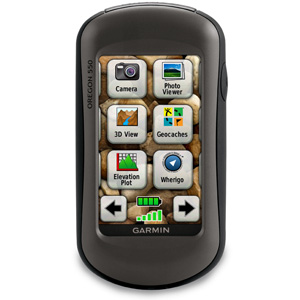
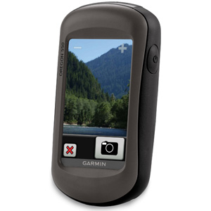
Garmin Oregon 550 Touch Screen GPS

The navigator with the photographic memory! Garmin Oregon 550 combines rugged outdoor touchscreen navigation with a 3.2 megapixel digital camera. Add high-sensitivity GPS, barometric altimeter, 3-axis electronic compass and a microSD™ card slot, and what do you get? A multipurpose device that will make your biggest adventures even more memorable.
Take Pictures and Save Locations
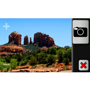
Capture locations and memories with Garmin Oregon 550’s 3.2 megapixel autofocus digital camera with 4x digital zoom. Each photo automatically is geotagged with the location of where it was taken, allowing you to navigate back to that exact spot in the future. Snap and view pictures in landscape or portrait orientation. With 850 MB of internal memory, you’ll never miss a photo opportunity. To store online, simply connect Oregon 550 via USB and visit myDashboard to upload and store your photos at Picasa™, a popular online photo sharing community. For more storage, insert a microSD card; you can even view pictures from other devices on microSD with Oregon’s picture viewer.
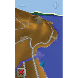
Touch and Go
Garmin Oregon 550 makes rugged navigation effortless with a tough, 3″ (7.62 cm) diagonal, sunlight-readable, color touchscreen display. The interface is easy to use, so you’ll spend more time enjoying the outdoors and less time searching for information. Both durable and waterproof, Garmin Oregon 550 is built to withstand the elements; bumps, dust, dirt, humidity and water are no match for this rugged navigator.
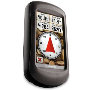
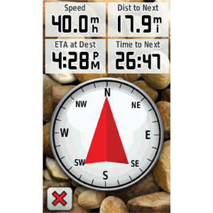
Get Your Bearings
Garmin Oregon 550 has a built-in 3-axis tilt-compensated electronic compass, which shows where you’re heading even when you’re standing still, without holding it level. Its barometric altimeter tracks changes in pressure to pinpoint your precise altitude, and you can use it to plot barometric pressure over time, which can help you keep an eye on changing weather conditions. And with its high-sensitivity, WAAS-enabled GPS receiver and HotFix® satellite prediction, Garmin Oregon 550 locates your position quickly and precisely and maintains its GPS location even in heavy cover and deep canyons.
Share Wirelessly
With Garmin Oregon 550 you can share your waypoints, tracks, routes and geocaches wirelessly with other compatible Oregon, Colorado® and Dakota® users. Now you can send your favorite hike to your friend to enjoy or the location of a cache to find. Sharing data is easy. Just touch “send” to transfer your information to similar units.
Add Maps
Adding more maps is easy with Garmin’s wide array of detailed topographic, marine and road maps. With its microSD™ card slot, Garmin Oregon 550 lets you load TOPO U.S. 24K maps and hit the trail, plug in BlueChart® g2 preloaded cards for a great day on the water or City Navigator map data for turn-by-turn routing on roads (see maps tab for compatible maps). Oregon 550 also supports BirdsEye Satellite Imagery (subscription required), that lets you download satellite images to your device and integrate them with your maps.
Find Fun
Garmin Oregon 550 supports OpenCaching.com GPX files for downloading geocaches and details straight to your unit. By going paperless, you’re not only helping the environment but also improving efficiency. Oregon stores and displays key information, including location, terrain, difficulty, hints and descriptions, which means no more manually entering coordinates and paper print outs! Simply upload the GPX file to your unit and start hunting for caches. Show off photos of your excursions with Oregon’s picture viewer. Slim and lightweight, Oregon is the perfect companion for all your outdoor pursuits.
Oregon 550: Picture the great outdoors.[/vc_tab][vc_tab title=”Specifications” tab_id=”specifications”]
| Physical & Performance: | |
| Unit dimensions, WxHxD: | 2.3″ x 4.5″ x 1.4″ (5.8 x 11.4 x 3.5 cm) |
| Display size, WxH: | 1.53″W x 2.55″H (3.8 x 6.3 cm); 3″ diag (7.6 cm) |
| Display resolution, WxH: | 240 x 400 pixels |
| Display type: | transflective color TFT touchscreen |
| Weight: | 6.8 oz (192.7 g) with batteries |
| Battery: | 2 AA batteries (included); NiMH or Lithium recommended |
| Battery life: | 16 hours |
| Waterproof: | Yes (IPX7) |
| Floats: | no |
| High-sensitivity receiver: | yes |
| Interface: | high-speed USB and NMEA 0183 compatible |
| Maps & Memory: | |
| Basemap: | yes |
| Ability to add maps: | yes |
| Built-in memory: | 850 MB |
| Accepts data cards: | microSD™ card (not included) |
| Waypoints/favorites/locations: | 2,000 |
| Routes: | 200 |
| Track log: | 10,000 points, 200 saved tracks |
| Features: | |
| Automatic routing (turn by turn routing on roads): | yes (with optional mapping for detailed roads) |
| Electronic compass: | yes (tilt-compensated, 3-axis) |
| Touchscreen: | yes |
| Barometric altimeter: | yes |
| Camera: | yes (3.2 megapixel with autofocus; 4x digital zoom) |
| Geocaching-friendly: | yes (paperless) |
| Custom maps compatible: | yes |
| Photo navigation (navigate to geotagged photos): | yes |
| Outdoor GPS games: | yes (Wherigo only) |
| Hunt/fish calendar: | yes |
| Sun and moon information: | yes |
| Tide tables: | yes |
| Area calculation: | yes |
| Custom POIs (ability to add additional points of interest): | yes |
| Unit-to-unit transfer (shares data wirelessly with similar units): | yes |
| Picture viewer: | yes |
| Garmin Connect™ compatible (online community where you analyze, categorize and share data): | yes |
What’s in the Box:
- Oregon 550
- AA battery charger
- 2 AA NiMH batteries
- Carabiner clip
- USB cable
- Manuals