Garmin Montana 650 Latest Mapping GPS
 Garmin Montana 650 Latest Mapping GPS
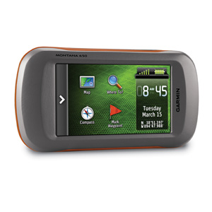
Take it hiking. Take it hunting. Take it on the water. Garmin Montana 650 features a bold 4 in. color touchscreen dual orientation display and supports multiple mapping options like BirdsEye Satellite Imagery and it has a 5 megapixel camera to boot. Montana has key features for the outdoors such as a 3-axis tilt-compensated compass and barometric altimeter. Buy the auto mount and a City Navigator NT® map and it’ll give you spoken turn-by-turn driving directions. It’s big. It’s versatile. It’s tough. It earned the name Montana – the ultimate in touchscreen toughness.
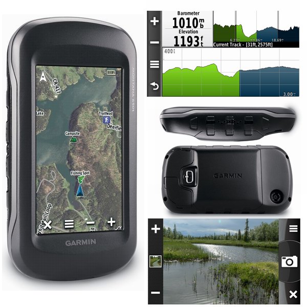
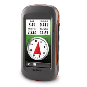
See the Big View
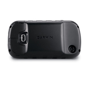
Garmin Montana 650 features a vast 4 in., sunlight-readable touchscreen display that offers crystal clear enhanced colors and displays high-resolution images. It’s easy-to-use interface means you’ll spend more time enjoying the outdoors and less time searching for information. Both durable and waterproof, Garmin Montana 650 is built to withstand the elements. Bumps, dust, dirt, humidity and water are no match for this rugged navigator. No matter the setting – on the boat, in the RV or on an ATV – Montana is right at home.
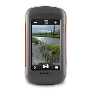
Take Geotagged Pictures
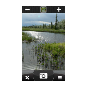
Capture locations and memories with Garmin Montana 650’s 5 megapixel digital camera. Each photo is geotagged automatically with the location of where it was taken, allowing you to navigate back to that exact spot in the future. Snap and view pictures in landscape or portrait orientation. To keep track of your photos and show their location on a map, simply connect Garmin Montana 650 via USB and use Garmin’s free BaseCamp software. For more storage, insert a microSD™ card; you can even view pictures from other devices on microSD with Montana’s picture viewer.
Go Anywhere
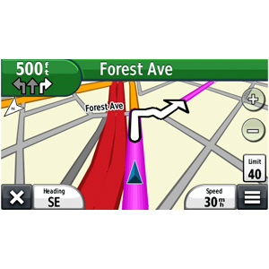
With an array of compatible mounts, Garmin Montana 650 is designed for use on ATV’s, in boats, as a handheld or in your car as a personal navigator. Use the auto mount with City Navigator maps for spoken, turn-by-turn driving directions, or the rugged mount for your motorcycle or ATV. Wherever you think you might take Montana, it has the mapping and mounts to get you there.
Go Everywhere
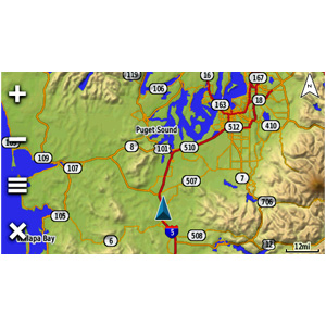
Adding more maps is easy with Garmin’s wide array of detailed topographic, marine and road maps. With its microSD™ card slot, Garmin Montana 650 lets you load TOPO U.S. 24K maps and hit the trail, plug in BlueChart® g2 preloaded cards for a great day on the water or City Navigator map data for turn-by-turn routing on roads (see maps tab for compatible maps). Garmin Montana 650 also supports BirdsEye Satellite Imagery (subscription required), that lets you download satellite images to your device and integrate them with your maps. In addition, Montana is compatible with Custom Maps, free software that transforms paper and electronic maps into downloadable maps for your device.
Share Wirelessly
With Garmin Montana 650 you can share your waypoints, tracks, routes and geocaches wirelessly with other compatible Garmin GPS users. So now your friends also can enjoy your favorite hike or cache – simply press “send” to transfer your information to similar units, and let the games begin.
Keep Your Fix
With its high-sensitivity, WAAS-enabled GPS receiver and HotFix® satellite prediction, Garmin Montana 650 locates your position quickly and precisely and maintains its GPS location even in heavy cover and deep canyons. The advantage is clear — whether you’re in deep woods or just near tall buildings and trees, you can count on Garmin Montana 650 to help you find your way when you need it the most.
Navigate with Ease
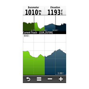
Garmin Montana 650 has a built-in 3-axis tilt-compensated electronic compass, which shows your heading even when you’re standing still, without holding it level. Its barometric altimeter tracks changes in pressure to pinpoint your precise altitude, and you even can use it to plot barometric pressure over time, which can help you keep an eye on changing weather conditions.
Double Your Power
Garmin Montana 650 features a one-of-a-kind dual battery system. You’ll have the option of using the rechargeable lithium-ion pack or traditional AA batteries – whichever suits your needs better.
Find Fun
Garmin Montana 650 supports geocaching GPX files for downloading geocaches and details straight to your unit. Visit OpenCaching.com to start your geocaching adventure. By going paperless, you’re not only helping the environment but also improving efficiency. Garmin Montana 650 stores and displays key information, including location, terrain, difficulty, hints and descriptions, which means no more manually entering coordinates and paper print outs! Simply upload the GPX file to your unit and start hunting for caches.
Plan Your Next Trip
Take charge of your next adventure with BaseCamp™, software to view and organize your maps, waypoints, routes, and tracks and send them to your Garmin device. This free trip-planning software displays topgraphic map data in 2-D or 3-D on your computer screen, including contour lines and elevation profiles. It also can transfer an unlimited amount of satellite images when paired with a BirdsEye Satellite Imagery subscription as well as geotag photos, or associate them with specific waypoints.
[/vc_tab][vc_tab title=”Features” tab_id=”features”]
Advanced Shortcut Features
Whether it’s loading an application, navigating to a waypoint, switching your profile or customizing specific settings to your needs, advanced shortcuts lets you combine these functions to create a custom-tailored, streamlined experience. Each Montana comes with pre-loaded shortcuts – Go Home, Track Log On/Off and Stop Navigation – to get you started.

More Dashboards in More Places
With 1 touch of the power button, you can pull up a multi-orientation dashboard from anywhere – your map, home screen, compass, trip computer, status page and more – so you can create more dashboards in more places.

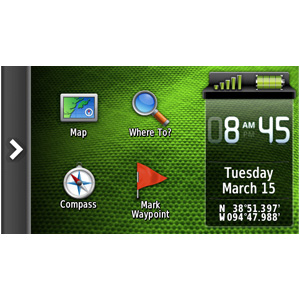
Fully Customizable Homescreen
Whether you go somewhere often, continually change settings or create shortcuts, Montana’s fully customizable home screen allows you to bring up to 16 items from “Where To?,” “Setup” and “Shortcuts” to your home screen so you can easily access them without having to click between screens.

Reorderable Menu Options
Reorder any menu however you like with this new feature, which keeps you from constantly scrolling to the bottom of a long list.

Smarter Profiles
Montana’s smarter profiles feature remembers which profile you were using, based on the mount, so when you’re off-roading or trying to find a bike shop, it will put you in the right frame of mind so you can get on your way quickly.

Adaptable Controls
Don’t like the way something is set up? No worries. With a tap of a button, you can configure your applications easily and quickly with adaptable controls. Have to mount on the right handle bar? No problem. Montana can accommodate left- or right-handed setups based on the screen orientation.
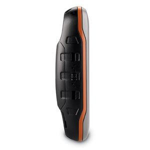
Big and Tough – Goes anywhere, everywhere
- Uses map data to display your “full track view” so you know what you’re up against.
- Logs everything (waypoints, tracks, caches, etc.) on your calendar so you can review (or brag) about your accomplishments later.
- Changes to “night mode” automatically so your eyes stay focused even when the sun goes down.
- Includes a QWERTY keyboard so you can find what you need and take notes faster.
- Helps you keep your bearings straight by letting you to lock your screen to keep it from shifting directions (portrait to landscape or vice versa).
- Includes a 5 megapixel camera; each photo automatically is geotagged with the location of where it was taken.
- Includes a microSD™ card slot so you can load topographic maps (for the trail) or BlueChart® g2preloaded cards (for the water). Also supports BirdsEye Satellite Imagery and Custom Maps.
- Shares waypoints, tracks, routes and geocaches wirelessly with other compatible Garmin GPS users.
- Locates your position quickly and precisely and maintains it even in heavy cover and deep canyons.
- Includes a built-in 3-axis tilt-compensated electronic compass and barometric altimeter.
- Features a one-of-a-kind dual battery system; you can use the rechargeable lithium-ion pack or traditional AA batteries.
- Supports geocaching GPX files for downloading geocaches and details straight to your unit.
Physical & Performance: |
|
| Unit dimensions, WxHxD: | 2.9″ x 5.7″ x 1.4″ (7.48 x 14.42 x 3.64 cm) |
| Display size, WxH: | 2″W x 3.5″H (5.06 x 8.93 cm); 4″ diag (10.2 cm) |
| Display resolution, WxH: | 272 x 480 pixels |
| Display type: | bright, transflective 65k color TFT, dual-orientation touchscreen; sunlight readable |
| Weight: | 10.2 oz (289 g) with included lithium-ion battery pack; 11.7 oz (333 g) with 3 AA batteries (not included) |
| Battery: | rechargeable lithium-ion (included) or 3 AA batteries (not included); NiMH or Lithium recommended |
| Battery life: | up to 16 hours (lithium-ion); up to 22 hours (AA batteries) |
| Waterproof: | yes (IPX7) |
| Floats: | no |
| High-sensitivity receiver: | yes |
| Interface: | high-speed USB and NMEA 0183 compatible |
Maps & Memory: |
|
| Basemap: | yes |
| Preloaded maps: | no |
| Ability to add maps: | yes |
| Built-in memory: | 3.0 GB |
| Accepts data cards: | microSD™ card (not included) |
| Waypoints/favorites/locations: | 4000 |
| Routes: | 200 |
| Track log: | 10,000 points, 200 saved tracks |
Features & Benefits: |
|
| Automatic routing (turn by turn routing on roads): | yes (with optional mapping for detailed roads) |
| Electronic compass: | yes (tilt-compensated, 3-axis) |
| Touchscreen: | yes |
| Barometric altimeter: | yes |
| Camera: | yes (5 megapixel with autofocus; automatic geo-tagging) |
| Geocaching-friendly: | yes (paperless) |
| Custom maps compatible: | yes |
| Photo navigation (navigate to geotagged photos): | yes |
| Outdoor GPS games: | no |
| Hunt/fish calendar: | yes |
| Sun and moon information: | yes |
| Tide tables: | yes |
| Area calculation: | yes |
| Custom POIs (ability to add additional points of interest): | yes |
| Unit-to-unit transfer (shares data wirelessly with similar units): | yes |
| Picture viewer: | yes |
| Garmin Connect™ compatible (online community where you analyze, categorize and share data): | yes |
What’s in the Box:
- Montana 650
- Lithium-ion battery pack
- USB cable
- AC charger
- Manuals