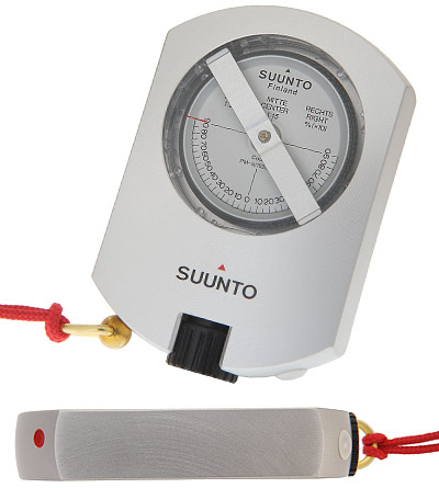
Suunto Tandem Clinometer with Precision Compass
The Suunto Tandem is a liquid-filled precision compass and clinometer in one compact aluminum housing. This instrument is an excellent tool for surveyors, engineers, cartographers, geologists, miners, architects and for anyone who needs to be able to measure directional indications, heights, vertical angles and slopes – with speed and accuracy.
Suunto Tandem 360PC/360R
- High accuracy – precise readings in seconds
- Durable aluminum housing – protects against impact, corrosion and water
- Edges at 90 degrees angles for contact measuring
- In-built spirit level
- Individually calibrated
- Optical adjustment for reading
- Lanyard
- Nylon pouch with belt-loop
- Same quality capsules as in the regular PMs and KBs
- Available for 5 geographic balancing zones
- 2-year warranty
- Dimensions: 120 x 76 x 15 mm
- Weight: 175 g / 6.2 oz
Available versions:
_Tandem 360 PC / 360 R: Scales: 0 ± 90°, 0 ± 150 %, conversion table: cosines 0 – 45°
_Tandem 360 PC / 360 RD: Scales: 0 ± 90°, 0 ± 150 %, conversion table: cosines 0 – 45°
_Tandem 400 PC / 400 R: Scales: 0 ± 100 gons, 0 ± 150 %, conversion table: cosines 0 – 50 gons
A combination of clinometer and precision compass
The Suunto Tandem is a liquid-filled precision compass and clinometer in one compact anodized alloy housing. This instrument is an excellent tool for satellite/antenna installers, surveyors, engineers, cartographers, geologists, miners, architects and for anyone who needs to be able to measure directional indications, heights, vertical angles and slopes – with speed and accuracy.
The Suunto Tandem is an invaluable aid in surveying and can also be used in mines, quarries and tunnels where inclines have to be measured with great accuracy. When surveying and constructing the Tandem is especially handy when there are obstacles or depressions in the line of vision. In addition, the Tandem assists in establishing GPS communication and installation and positioning of satellite antenna. It helps in establishing the right direction, the correct angle and that the location is free from obstacles.
The Suunto Tandem features a lanyard, and a convenient carrying pouch with a belt loop. You can change the Tandem from compass to clinometer with a turn of your wrist.
Five Geographical Balancing Zones
The vertical intensity and direction of the earth’s magnetic field, the inclination, influences the horizontal plane of a compass needle according to the latitude where it is used. Due to inclination, compasses must be balanced for different geographical zones in order to keep the needle in a horizontal position.
The Suunto precision instruments are balanced to five different geographic balancing zones to ensure the best possible performance in each region. The demand for high accuracy and reliability from the professionals using these instruments requires geographic localization of the compass.