Leica Digicat 600

Series – Making Cable Avoidance Easier and Safer
The latest Digicat 600i and 650i provide data-logging capabilities and Bluetooth connectivity for wireless data transfer.
Leica Digicat 600i and 650i locate buried conductive services by receiving electromagnetic signals which radiate from them. The newly developed Logicat software interprets the signals and provides the operator with an audible and visual response to the position and direction of the buried services.
The Leica Digicat 600i and 650i locate buried conductive services by receiving electromagnetic signals which radiate from them. The Digicat’s software interprets the signals and provides the operator with an audible and visual response to the position and direction of the buried services.
Buried service location has never been so easy…
 |
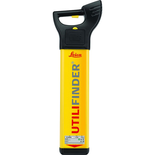
Digicat 600i locatorProvides a unique data capture and on board memory function, allowing verification of the locators use and the ability to recall records following a near miss, service strike or similar incident. The Leica Digicat 600i locates buried conductive services by receiving electromagnetic signals which radiate from them. The Digicat’s intelligent software interprets the signal data and provides the operator with an audible response to the location and direction of buried utilities. The operator can mark the ground or use a GIS mapping device to note the location. With the unique Logicat Software, records can be retrieved and collated helping to increase on site safety, whilst identifying training needs. |
 |
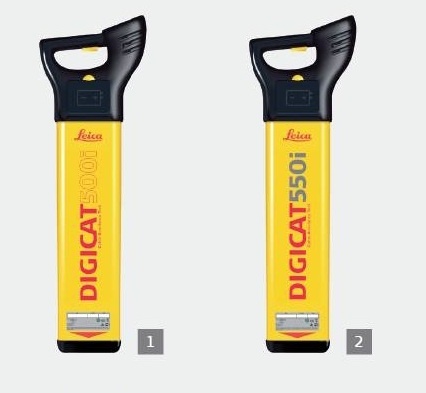
Digicat 650i locatorContains the same functionality as the Leica Digicat 600i, however it offers the added benefits of data logging, Bluetooth Wireless Connectivity and service depth indication, when used in conjunction with the Leica Digitex 100t signal generator or Sonde in 8/33 kHz mode. With the unique Logicat Software, records can be retrieved and collated helping to increase on site safety, whilst identifying training needs. |
 |
Leica Digitex 100t Signal TransmitterDesigned in conjunction with the Digicat locator, to easily and accurately trace the route of, or locate, an underground cable or metal pipe that does not carry a naturally present signal. The Digitex 100t generates a specific “active” signal, which can then be traced using the Digicat. It allows users to trace services over a greater distance, improve service detection in areas of high signal interference and improves depth estimation when using a depth locator. |
Leica Digicat 600i / 650i Feature Matrix
| Features | Digicat 600i | Digicat 650i |
| Frequency / Mode | Power mode 50 Hz or 60 Hz, Radio mode 15 kHz to 60 kHz Generator mode 8 kHz and 33 kHz, Auto mode = Power + Radio mode |
Power mode 50 Hz or 60 Hz, Radio mode 15 kHz to 60 kHz Generator mode 8 kHz and 33 kHz, Auto mode = Power + Radio mode |
| Depth | Power to 3m, Radio to 2m, Generator mode to 3m |
Power to 3m, Radio to 2m, Generator mode to 3m |
| Depth estimation | 10% of depth in line or sonde (0.3 to 3m depth range) |
|
| Protection | Conforms to IP54 | Conforms to IP54 |
| Bluetooth | enabled | enabled |
| Batteries | 6 x AA alkaline(IEC LR6 supplied) | 6 x AA alkaline(IEC LR6 supplied) |
| Battery life | 40 hours intermittent use (at 20°C) | 40 hours intermittent use (at 20°C) |
| Weight | 2.7kg including batteries | 2.7kg including batteries |
| Compatibility | CSV file compatibility program | CSV file compatibility program |
| Memory size | 32Mb memory | 32Mb memory |
| Capability | 80hrs of data | 80hrs of data |
Leica Digitex 100t Signal Transmitter Feature Matrix
| Features | Digitex 100t |
| Operating transmission Frequencies | • 8.192kHz • 32.768kHz • Mixed 8/33 |
| Output Power | 4 levels |
| Induction (Max) | Up to 1W max |
| Direct Connection (100Ohms) | Up to 1W max when connected to a buried service with an impedance of 1000hms |
| Battery Type | 4 x D alkaline (IEC LR20), supplied |
| Battery Life | 30hrs intermittent use (at 20°C) |
| Weight | 2.4kg/5.3lbs including batteries |
| Dimensions | 180mm (H) x 260mm (D) x 280mm (W) |
| IP Rating (Case Lid Closed) |
IP65 |
| IP Rating (Case Lid Open) |
IP54 |
Brochure
[/vc_tab] [/vc_tabs]About Leica Geosystems – when it has to be right
With close to 200 years of experience pioneering solutions to measure the world, Leica Geosystems products and services are trusted by professionals worldwide to help them capture, analyze, and present spatial information. Leica Geosystems is best known for its broad array of products that capture accurately, model quickly, analyze easily, and visualize and present spatial information.
Those who use Leica Geosystems products every day trust them for their dependability, the value they deliver, and the superior customer support. Based in Heerbrugg, Switzerland, Leica Geosystems is a global company with tens of thousands of customers supported by more than 3,500 employees in 28 countries and hundreds of partners located in more than 120 countries around the world. Leica Geosystems is part of the Hexagon Group,