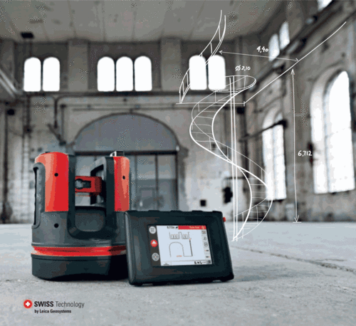
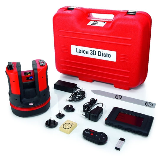
Leica 3D Disto – Laser measurement system.
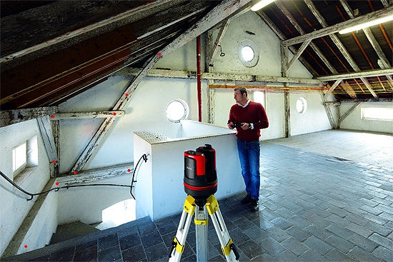
Large room? No right angles? Skewed walls? Many details? Difficult to reach? No cause to worry: The Leica 3D Disto Laser Distance Meter measures everything you need. Ladder? Mobile access platform? You can leave them back at base. No tripod on hand? Makes no difference – simply place the 3D Disto on a table or the floor. Levelling up? Not necessary. Photographs for the records? No problem, the in-built camera provides the pictures.

Leica 3D Disto Tools – Simple, Practical, Quick

Quick plumbing
Perfect for plumbing points up or down – without having to stand over the plumbing point: you measure to the point to be plumbed. The laser dot shows you the precise position of the plumbed point.
 Quick Staking out
Mark a point and easily on a wall: Simply point, define the horizontal or vertical distance. The desired point is displayed at the press of a button.
 Parallel lines
Measure two points on a straight line and enter a parallel distance. Wherever your known point. The laser dot moves precisely on the parallel line.

Level
Mark and measure the reference points at the same height on the walls and sloping surfaces. Installing e.g Ceiling tracks: Simply measure the reference point and point at the stakeout position.

Level reference plates
Attach the level markings and measure the height differences to a reference point. Ideal e.g. for attaching and transferring level reference plates.

Height control
Some height are difficult to determine because you cannot measure a direct distance, e.g. with trees or overhead power lines in the way. Just measure one point. The height is calculated.
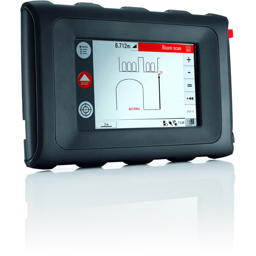
Leica 3D Disto Measuring a room – It is this simple to create a room
Details are everything when measuring up a room. The application program “Room Scan” provides additional functions for measuring wall surfaces and automatically measures area predefined by you. You can also reference your measurements to your site’s level datum
Measure from room to room
With the option “New station point” measuring from one room to the other is child’s play.
- You can save, change and check your station point
- Continue with the measurements after you have changed the station point of the Leica 3D Disto
- Further measurements can be added to previously stored data at any time

With the Leica 3D Disto you can measure all wall surfaces including windows, doors and pipe connections.

It is all done from the station point: You simply measure from one room to the next.
The big plus with the Leica 3D Disto
- Suitable for all the measurements in the room.
- Measurement of separate points referenced to level datum.
- Automatically measure all wall surfaces, horizontal or vertical: simply define the area to be measured, the spacing between measurements and start. No detail is forgotten, angles and out of plane features are captured.
- Automatic creation of drawings with borders, folding marks and data export: Data can be printed without the need for further processing.
- Useful tools for measuring windows and pipe connections reduce the amount of work involved.
- Fold-out mode: change from plan to elevation for measuring the details on walls, for viewing visualizations or for checking previously measured values/points.
Leica 3D Disto Projector – Layout has never been so simple
With the software application “Projector” you can create patterns and grids of existing layouts on the floor, ceiling or wall surfaces. Point for point. One press on the remote control and the next point is displayed. Perfect when you are standing on a ladder or a scaffold and have your hands full.

Point for point precision
- Determine your grid manually or import it from a preprepared DXF file
- Simply select and measure the first point in plan – and the laser automatically shows the position. It’s done!
- Practical tools to help you adjust your methods to suit the surface
- And all you need is the remote control, which you use to conveniently control the stakeout from your station point
 Leica 3D Disto All Stored -Nothing gets lost
 Leica 3D Disto All Stored -Nothing gets lost
Say goodbye to illegible hand sketches! The Leica 3D Disto records every measurement. The file management system comprehensibly documents all your projects, measured data and photos, making them available to you for further processing
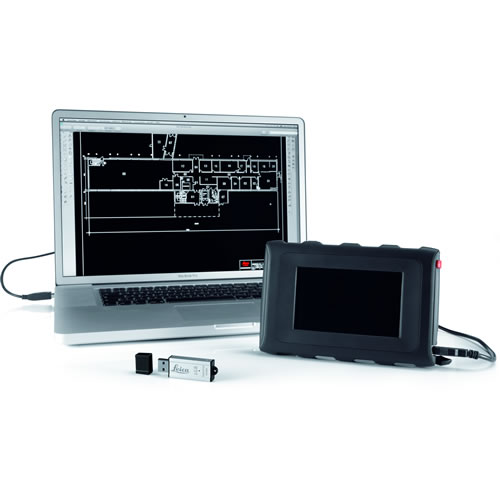
Perfect interfacing with your PC
All data is prepared for export to your PC or US B stick at the touch of a button. Standard data formats for lists, tables, photos and drawings mean the results can be readily imported, viewed and further processed.

The latest product from the laser measuring pioneer – Three dimensions – one solution

- Measure plan position, height and distance,
- in all three spatial axes
- Intuitive user guidance from Assistants
- Measure from one station – every visible point can be measured by targeting with the visible laser dot –without the need to walk to the target
- Measure to difficult-to-reach points, such as roof edges
- As-built records of ceiling, floor and roof surfaces,
- volumes, inclination, falls, height differences, angles
- Plumbing of points, parallel offsetting of axis, levelling,
- transferring levels from wall to wall. Forget spirit level
- and measuring tapes!
- Realtime display of measurements as drawings
- on the screen
- Positionally accurate representation of the measured
- points in the camera display
- Pocket calculator
- Recording information in the form of standard tables,
- photos, DXF files, text files at the press of a button
- Remote control measurements
- Data import and export on PC and US B stick
Leica 3D Disto Has All This

- Precision: Accurate to 1 mm at 10 m.
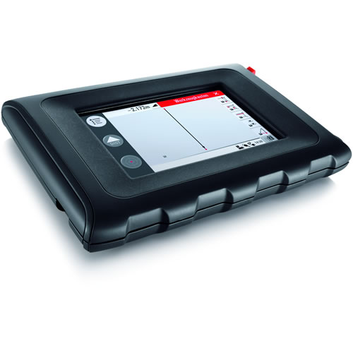
- Hand-held unit with a modern touch screen, high-resolution color display.
- Wireless connection between sensor and hand-held unit eliminates the hassle and limitation of cables. Walk to your target and see where you are measuring.
- Digital pointfinder with 8x zoom for precise pointing over longer distances.
- Integrated camera.
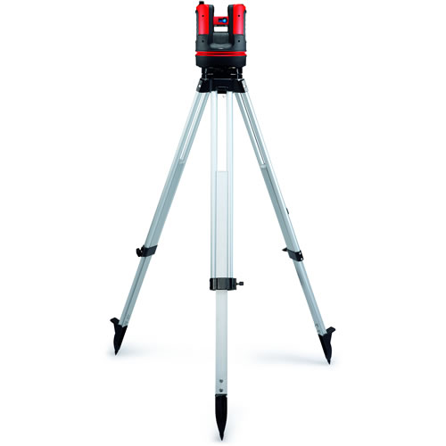
- Sensor can be placed on any stable surface or mounted on a tripod using the 5 ⁄ 8″ thread.
Technical Specifications – At a Glance
| Features of goniometer (HZ/V) | Range of measurement | Horizontal 360º; vertical 250º |
| Accuracy | 5″, equates to 1.2mm @ 50m | |
| Features of laser distance meter | Type | Coaxial, visible red laser |
| Range of measurement | 0.5 – 50m | |
| Laser class | 2 | |
| Laser type | 650nm; < 1mW | |
| ⌀ laser dot (at distance) | 10m: ~7mm x 7mm30m: ~9mm x 15mm | |
| Tie distance accuracy (3D)Combination of angle and distance | @ 10m @ 30m @50mApprox. 1mm 2mm 4mm | |
| Tilt sensor | Self levelling range | ± 3∘ |
| Accuracy | 10″, equates to 2.5mm @ 50m | |
| Digital pointfinder | Zoom (magnification) | 1x, 2x, 4x, 8x |
| Field of view (@ 10m) | 1x: 3.40m x 2.14m 2x: 1.70m x 1.07m 4x: 0.85m x 0.54m 8x: 0.42m x 0.27m |
|
| Circular level setting accuracy* | 1∘/mm | |
| Operation | Screen | High-resolution screen, 800 x 480 pixels, 4.8″ TFT LCD, 16 million colours |
| Keys / user interface | 3D Disto: 1 On / Off button Hand-held unit : touch screen, 1 On / Off button |
|
| Memory | Flash memory 32 GB | |
| Interfaces | 3D Disto: USB type B, power supply pack, power supply to hand-held unit Hand-held unit: USB type A, power supply pack | |
| Communication | Cable | USB : Micro-B USB type A, WLAN |
| Wireless | SD card, range: 50m (depending on environment) | |
| Data format | Import DXF; export DXF, TXT, CSV, JPG | |
| Power Supply | Type | 3D Disto: Li-Ion battery, voltage: 14.4V / 63Wh, external power supply: 24VDC / 2.5A, charging time 8hHand-held unit: Li-Ion battery, 2500mAh, 3.7V, external power supply: 5VDC/ 2.0A, charging time 7h |
| Operating time | 3D Disto: 8h Hand-held unit: 6h |
|
| Attachment | 5/8″ thread | |
| Dimensions (WxHxD) | 3D Disto: ⌀186.6 x 215.5mm Hand-held unit: 178.5 x 120 x 25.8mm |
|
| Weight | 3D Disto: 2.8kg Hand-Held unit: 0.33kg |
|
| Environmental conditions | Operating temperature range | 3D Disto: -10 to 50 ℃ Hand-held unit: -10 to 50 ℃ |
| Storage temperature | 3D Disto -25 to 75 ℃ Hand-held unit: -25 to 70 ℃ |
|
| Water and dust protection | 3D Disto: IP54 (IEC 60529) Hand-held unit: IP5x |
|
| Moisture | Max. 85%, non-condensing | |
| Remote control (IR) | Range | 50m (depending on environment) |
| Communication | Infrared (IR) | |
| Battery | 1AA, 1.5V |
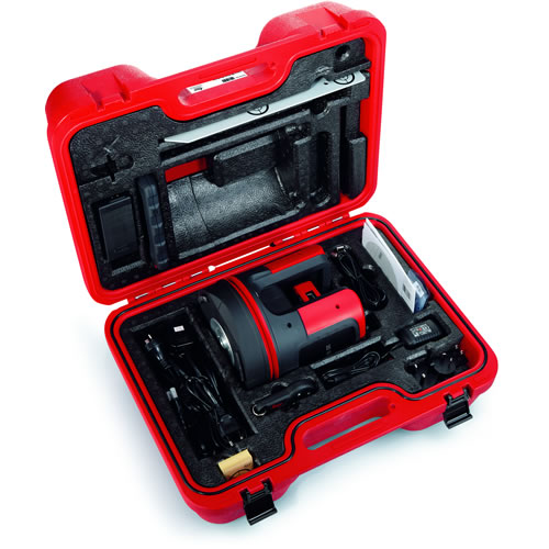
Leica 3D Disto Delivery Package:

- 1 No. 3D Disto with built-in SD WLAN card
- 1 No. Control Unit with stylus, tripod clamp and hand strap
- 1 No. Ruler for offset points
- 50 Nos. Target marks, self-adhesive
- 1 No. RM100 Remote Control
- 1 No. Industrial Grade USB Stick
- 1 No. 3D Disto Charger
- 1 No. Control unit charger
- 1 No. 3D Disto to control unit USB cable
- 1 No. Control unit to PC micro USB cable
- 1 No. Safety Instructions Manual
- 1 No. CE & Producer Certificate
- 1 No. 3D Disto Quick Start


Leica 3D Disto Slope Area Demo Video
Leica 3D Disto Room Scan Demo Video
Leica 3D Disto Projector Demo Video
Leica 3D Disto Relocation Demo Video
Brouchures
Manuals
About Leica Geosystems – when it has to be right
With close to 200 years of experience pioneering solutions to measure the world, Leica Geosystems products and services are trusted by professionals worldwide to help them capture, analyze, and present spatial information. Leica Geosystems is best known for its broad array of products that capture accurately, model quickly, analyze easily, and visualize and present spatial information.
Those who use Leica Geosystems products every day trust them for their dependability, the value they deliver, and the superior customer support. Based in Heerbrugg, Switzerland, Leica Geosystems is a global company with tens of thousands of customers supported by more than 3,500 employees in 28 countries and hundreds of partners located in more than 120 countries around the world. Leica Geosystems is part of the Hexagon Group,